My Alama Mater- St.Joseph's College, Colombo, Sri Lanka

St. Joseph's College is a Catholic educational institution in Colombo, Sri Lanka. It was established in 896 by French missionaries, with Rev Christophe-Etienne Bonjean playing a leading role. The college has over 4500 students with a staff of over 400. Distinguished former students include Cardinal Thomas Cooray the first Cardinal from Sri Lanka, and President Ranasinghe Premadasa. The motto of the college is "In Scientia et Virtute", meaning "In Knowledge and Virtue" in Latin.


                                                   Showing part of front view of the college.


                                                     Showing the Chapel of St. Joseph’s College.  

                                                                            
                                                                       Logo of the College


St. Joseph's College is a Catholic educational institution in Colombo, Sri Lanka. It was established in 1896 by French missionaries, with Rev Christophe-Etienne Bonjean playing a leading role. The college has over 4500 students with a staff of over 400. Distinguished former students include Cardinal Thomas Cooray the first Cardinal from Sri Lanka, and President Ranasinghe Premadasa. The motto of the college is "In Scientia et Virtute", meaning "In Knowledge and Virtue" in Latin.

Religious affiliation(s): Roman Catholic

Established: 2 March 1896

Present Rector: Rev. Fr. Travis Gabriel

Staff:450

Grades: 1 to 13 Local Syllabus & London A/L's

Gender: Boys

Age:5 to 19

Color(s): Blue & White


Why are Ships called She?

 "A ship is called a she because there is always a great deal of bustle around her; there is usually a gang of men about; she has a waist and stays; it takes a lot of paint to keep her good-looking; it is not the initial expense that breaks you, it is the upkeep; she can be all decked out; it takes an experienced man to handle her correctly; and without a man at the helm, she is absolutely uncontrollable. She shows her topsides, hides her bottom and, when coming into port, always heads for the buoys.”

 But seriously: why are ships and countries (and sometimes cars and other vessels and vehicles) often referred to with the feminine pronoun? Although the practice has been in steady decline for some time now, thanks no doubt to feminism and PC journalistic style guides it’s nevertheless been historically ingrained in nautical language and lore for many centuries. One prosaic explanation is that the gender of the Latin word for “ship” — Navis — is feminine. But people generally agree on the more romantic notion of the ‘ship as a she’ phenomenon: that it stems from the tradition of boat-owners, typically and historically male, naming their vessels after significant women in their lives — wives, sweethearts, mothers.

Similarly, and more broadly, ships were once dedicated to goddesses, and later also to mortal women of national or historic significance, thereby bestowing a benevolent feminine spirit on the vessels that would carry seafarers across treacherous oceans. Figureheads on the prows of ships were often depictions of such female namesakes, denoting the name of the ship for a largely illiterate maritime population. This practice dated from the early 18th century, before which superstition had it that the presence of women aboard sailing vessels — whether in human or representative form — was an omen of bad luck.

The practice of naming boats and ships after women continues today, although certainly not exclusively, as does the habit of feminizing our sailing vessels.

Troubled Waters's photo.


My Old Home Town - and little bit of its history

Galle is a major city in Sri Lanka, situated on the southwestern tip, 119 km from Colombo. It is the administrative capital of Southern Province, Sri Lanka and is the district capital of Galle District. Galle is the fifth largest city in Sri Lanka after the capital Colombo, Kandy, Jaffna and Negombo.

Galle was known as Gimhathiththa (although Ibn Batuta in the 14th century refers to it as Qali)before the arrival of the Portuguese  in the 16th century, when it was the main port on the island. Galle reached the height of its development in the 18th century, during the Dutch colonial period. Galle is the best example of a fortified city built by the Portuguese in South and Southeast Asia, showing the interaction between Portuguese architectural styles and native traditions. The city was extensively fortified by the Dutch during the 17th century from 1649 onwards. The Galle fort is a world heritage site and is the largest remaining fortress in Asia built by European occupiers.


Other prominent landmarks in Galle include the city's natural harbor, the National Maritime Museum, St. Mary's Cathedral founded by Jesuit priests, one of the main Shiva temples on the island, and Amangalla the historic luxury hotel. On 26 December 2004 the city was devastated by the massive Tsunami. Thousands were killed in the city alone. Galle is home to a cricket ground, the Galle  International Stadium which is considered to be one of the most picturesque cricket grounds in the world. The ground which was severely damaged by the tsunami, was rebuilt and test matches resumed there on December 18, 2007.


Important natural geographical features in Galle include Rumassala in Unawatuna, a large mound-like hill, which forms the eastern protective barrier to the Galle harbour. Local tradition associates this hill with some events of Ramayana, one of the great Hindu epics. The major river in the area is the Gin River (Gin Ganga), which begins from Gongala Kanda and passes villages such as Neluwa, Nagoda, Baddegama, Thelikada and Wakwella, reaches the sea at Ginthota. The river is bridged at Wakwella by the Wakwella Bridge.

Western side of Galle Harbor and Galle Fort.


Clock tower in Galle Fort


National Maritime Museum 


Our house was in Richmond Hill and was very close to Richmond College.  At that time, about 90% of the families who lived in Richmond Hill were Sinhala, Buddhists. Christians were the minority but we all lived in harmony as one family.

My parents made early plans about my education. When I was about four years old, they discussed with the Parish priest of the Kalegana church (our local parish) who opened a Montessori school for little ones in the area and very specially for me. Eventually I first attended the Montessori school in Kalegana, Galle

My family left Richmond Hill and moved to Colombo in 1961.

Richmond Hill Railway Station


Wesleyan Methodist Chapel, at Galle,
Ceylon (1868)

The Richmond Hill railway station is the first railway station in Sri Lanka built and named after a school. The Richmond Hill Station is located on the Coastal line between the Piyadigama railway station and Galle Railway Station. It was constructed during the early 1900s for the benefit of children who attend the many schools around the area. The station is located at the base of the hill approximately 200 m (660 ft) from the Richmond Hill Road.


Tsunami - part 2 (SFGD)


Generation mechanisms


The principal generation mechanism (or cause) of a tsunami is the displacement of a substantial volume of water or perturbation of the sea. This displacement of water is usually attributed to either earthquakes, landslides, volcanic eruptions, glacier calvings or more rarely by meteorites and nuclear tests. The waves formed in this way are then sustained by gravity. Tides do not play any part in the generation of tsunamis.


Seismicity

Tsunami can be generated when the sea floor abruptly deforms and vertically displaces the overlying water. Tectonic earthquakes are a particular kind of earthquake that are associated with the Earth's crustal deformation; when these earthquakes occur beneath the sea, the water above the deformed area is displaced from its equilibrium position. More specifically, a tsunami can be generated when thrust faults associated with convergent or destructive plate boundaries move abruptly, resulting in water displacement, owing to the vertical component of movement involved. Movement on normal (extensional) faults can also cause displacement of the seabed, but only the largest of such events (typically related to flexure in the outer trench swell) cause enough displacement to give rise to a significant tsunami.


Drawing of tectonic plate boundary before earthquake:

 Generation mechanisms


The energy released produces tsunami waves.


Tsunami


Tsunami is originally from Japanese language meaning: "harbor wave". It is also known as a seismic sea wave, is a series of waves in a water body caused by the displacement of a large volume of water, generally in an ocean or a large lake. Earthquakes, volcanic eruptions and other underwater   explosions including detonations of underwater nuclear devices, landslides, glacier calvings, meteorite impacts and other disturbances above or below water all have the potential to generate a tsunami. Unlike normal ocean waves which are generated by wind or tides, which are generated by the gravitational pull of the Moon and Sun, a tsunami is generated by the displacement of water.


Tsunami waves do not resemble normal sea waves, because their wavelength is far longer. Rather than appearing as a breaking wave, a tsunami may instead initially resemble a rapidly rising tide, and for this reason they are sometimes referred to as tidal waves, although this usage is not favored by the scientific community because tsunamis are not tidal in nature. Tsunamis generally consist of a series of waves with periods ranging from minutes to hours, arriving in a so-called "wave train". Wave heights of tens of meters can be generated by large events. Although the impact of tsunamis is limited to coastal areas, their destructive power can be enormous and they can affect entire ocean basins; the 2004 Indian Ocean tsunami was among the deadliest natural disasters in human history with at least 230,000 people killed or missing in 14 countries bordering the Indian Ocean.


Deepest Part of the Worlds's Oceans

The Mariana Trench or Marianas Trench is the deepest part of the world's oceans. It is located in the western Pacific Ocean, to the east of the Mariana Island. The trench is about 2,550 kilometres (1,580 mi) long but has an average width of only 69 kilometres (43 mi). It reaches a maximum-known depth of 10,994 m (± 40 m) or 6.831 mi (36,070 ± 131 ft) at the Challenger Deep, a small slot-shaped valley in its floor, at its southern end, although some unrepeated measurements place the deepest portion at 11.03 kilometres (6.85 mi).

At the bottom of the trench the water column above exerts a pressure of 1,086 bars (15,750 psi), over 1000 times the standard atmospheric pressure at sea level. At this pressure, the density of water is increased by 4.96%, making 95 litres of water under the pressure of the Challenger Deep contain the same mass as 100 litres at the surface. The temperature at the bottom is 1 to 4 °C.

The trench is not the part of the seafloor closest to the center of the Earth. This is because the Earth is not a perfect sphere; its radius is about 25 kilometres (16 mi) less at the poles than at the equator.As a result, parts of the Arctic Ocean seabed are at least 13 kilometres (8.1 mi) closer to the Earth's center than the Challenger Deep seafloor.

Coriolis Force in relation to the movement of Topical Revolving Storms

 
An effect whereby a mass moving in a rotating system experiences a force (the Coriolis force) acting perpendicular to the direction of motion and to the axis of rotation. On the earth, the effect tends to deflect moving objects to the right in the northern hemisphere and to the left in the southern and is important in the formation of cyclonic weather systems.

Tropical Revolving Storms

What they are?

A tropical storm is an intense low pressure weather system, that can last for days to weeks within the Tropical regions of our planet.  They are tropical revolving storms because they are spun on their journey by the Coriolis force of the Earth’s spin.    The Earth is 40,000 kilometers (24,900 miles) around at its widest part, the equator. Because it spins on its axis once in 24 hours, a point on the Earth's equator is traveling about 1,700 km per hour (1,000 miles per hour) relative to its axis. But the closer you get to the poles, the smaller the track a point takes in its daily rotation. At 60° North or South latitude, the track is only half the distance that it is at the equator, and so a point travels only half as fast. Air (or water) moving from high latitudes to low then tends to lag, and a person on the surface would feel a wind blowing out of the east. On the other hand, air moving from low latitudes to high is deflected westwards. This also means that moving air or water is deflected to the right in the northern hemisphere, and to the left in the southern hemisphere.  It is this deflection that causes tropical storms to rotate.
 
Where they occur:
Tropical storms are known by many names, including hurricanes (North America), cyclones (India) and typhoons (Japan and East Asia).   They all occur in a band that lies roughly between the tropics of Cancer and Capricorn and despite varying wind speeds are ferocious storms. Some storms can form just outside of the tropics, but in general the distribution (location) of these storms is controlled by the places where sea temperatures rise above 27°C and is heated to a sufficient depth.
The highest number of storms does not occur in the Atlantic close to the USA, but in the North Pacific affecting countries such as the Philippines and Japan. This is despite the fact that in the UK we only really get to hear about tropical storms affecting the USA. The most affected area being South East Asia receives an average of 26 storms per year. The least affected area is India where there is an average of 2 tropical storms per year.

Tropical Storm - Eye


The Saffir-Simpson Scale:

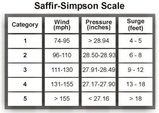
Tropical storms are defined by their wind speeds and the potential damage they can cause, using what is known as the Saffir Simpson scale. Many tropical storms form between the tropics, some develop into tropical depressions but not many actually develop into full blown hurricanes/cyclones/typhoons.  As the sea temperature increases uplift of air increases and pressure decreases.  The Saffir Simpson also accounts for the height of the storm surge, the huge waves of water that are whipped up by the storms.
 
The Saffir-Simpson scale for Hurricane Classification

Wind speeds are used to decide what category of storm a tropical storm is, over 120Kph or 74 mile per hour is needed for a category 1 hurricane, Over 250Kph or 149 miles per hour is the worst hurricane, a category 5 which would cause extreme damage.  Watch  an animation of the Saffir-Simpson scale in action.

How Tropical storms form:
Tropical storms form whenever sea temperatures rise above 27 °C and can be up to 650km across. They occur where the trade winds converge and often when the ITCZ has migrated to its most Northerly extent allowing air to converge or come together at low levels.   The suns heat passes through our atmosphere and warms the ocean water throughout the summer.  The sea is constantly moving and heat is redistributed to deeper parts of the ocean so this takes quite some time (this is why hurricanes occur in late summer - when sea temperature is at its highest).
This causes the seas temperature to rise to 27°C and above, which encourages evaporation and the rising of air and water vapor up through the atmosphere in thermals. As these thermals rise the temperature drops (at 9.7°C per 1000m ascent or the DALR).  Progressively the relative humidity rises as the air ascends (as cooler air can hold less water vapour than warmer air), eventually this causes the water vapour to condense into tiny droplets around dust and pollen (condensation nuclei).  These droplets collide together to form bigger droplets and thus helps to form huge cumulonimbus clouds. Latent heat is released during condensation fueling the storm further. Eventually these droplets will collide and coalesce with one another, become bigger and fall as rain. As a result of condensation, latent heat is released and the air cools at a slower rate, the SALR, this fuels the storm further.
Because the air has risen in the center of this storm, an area of low atmospheric pressure exists at the surface.  The Earth's atmosphere acts to balance this out as air rushes from surrounding high pressure areas to the centre of the storm along the pressure gradient.  This creates the high winds in the storm, and the lower the pressure gets in the centre of the storm relative to the pressure surrounding the storm, the stronger the winds will become as the pressure gradient steepens.
The whole storm slowly migrates across oceans towards land, and because of the Earth’s rotation or spin (known as the Coriolis force or effect (click here to see an animation)), the whole storm starts to spiral around a central more calm point, known as the eye. The pressures and weather are more stable in the eye, as the updrafts of air are balanced by descending cooled air.
As tropical storms pass over land they lose their source of energy, and the die out.

Drakes Voyage to Coast of California: Nova Albion (1579)

The journey of Francis Drake up the Pacific Coast in 1579, artist's impression.


After looting the Cacafuego, Drake turned north, hoping to meet another Spanish treasure ship coming south on its return from Manila to Acapulco. Although he failed to find a treasure ship, Drake reputedly sailed as far north as the 38th parallel, landing on the coast of California on 17 June 1579. He found a good port, landed, repaired and restocked his vessels, then stayed for a time, keeping friendly relations with the Coast Miwok natives. He claimed the land in the name of the Holy Trinity for the English Crown, called Nova Albion—Latin for "New Britain". Assertions that he left some of his men behind as an embryo "colony" are founded on the reduced number who were with him in the Moluccas.

Drake's landing in California, engraving published 1590 by Theodor de Bry.

The precise location of the port was carefully guarded to keep it secret from the Spaniards, and several of Drake's maps may have been altered to this end. All first-hand records from the voyage, including logs, paintings and charts, were lost when Whitehall Palace burned in 1698. A bronze plaque inscribed with Drake's claim to the new lands – Drake's Plate of Brass – fitting the description in his account, was discovered in Marin County, California but was later declared a hoax. Now a National Historic Landmark, the officially recognized location of Drake's New Albion is Drakes Bay, California.

Ancient Navigators: Sir Francis Drake

Sir Francis Drake, Vice Admiral was an English sea captain, privateer, navigator, slaver, and politician of the Elizabethan era. Elizabeth I of England awarded Drake a knighthood in 1581. He was second-in-command of the English fleet against the Spanish Armada in 1588. He also carried out the second circumnavigation of the world, from 1577 to 1580.


At age 23, Drake made his first voyage to the New World, sailing with his second cousin, Sir John Hawkins, on one of a fleet of ships owned by his relatives, the Hawkins family of Plymouth. In 1568 Drake was again with the Hawkins fleet when it was trapped by the Spaniards in the Mexican port of San Juan de UlĂșa. He escaped along with Hawkins.

Following the defeat at San Juan de UlĂșa, Drake vowed revenge. He made two voyages to the West Indies, in 1570 and 1571, of which little is known.

In 1572, he embarked on his first major independent enterprise. He planned an attack on the Isthmus of Panama, known to the Spanish as Tierra Firme and the English as the Spanish Main. This was the point at which the silver and gold treasure of Peru had to be landed and sent overland to the Caribbean Sea, where galleons from Spain would pick it up at the town of Nombre de Dios. Drake left Plymouth on 24 May 1572, with a crew of 73 men in two small vessels, the Pascha (70 tons) and the Swan (25 tons), to capture Nombre de Dios.

His first raid was late in July 1572. Drake and his men captured the town and its treasure. When his men noticed that Drake was bleeding profusely from a wound, they insisted on withdrawing to save his life and left the treasure. Drake stayed in the area for almost a year, raiding Spanish shipping and attempting to capture a treasure shipment.

In 1573, he joined Guillaume Le Testu, a French buccaneer, in an attack on a richly laden mule train. Drake and his party found that they had captured around 20 tons of silver and gold. They buried much of the treasure, as it was too much for their party to carry. (An account of this may have given rise to subsequent stories of pirates and buried treasure.) Wounded, Le Testu was captured and later beheaded. The small band of adventurers dragged as much gold and silver as they could carry back across some 18 miles of jungle-covered mountains to where they had left the raiding boats. When they got to the coast, the boats were gone. Drake and his men, downhearted, exhausted and hungry, had nowhere to go and the Spanish were not far behind.

At this point Drake rallied his men, buried the treasure on the beach, and built a raft to sail with two volunteers ten miles along the surf-lashed coast to where they had left the flagship. When Drake finally reached its deck, his men were alarmed at his bedraggled appearance. Fearing the worst, they asked him how the raid had gone. Drake could not resist a joke and teased them by looking downhearted. Then he laughed, pulled a necklace of Spanish gold from around his neck and said "Our voyage is made, lads!" By 9 August 1573, he had returned to Plymouth